Jump to content
NEW PALMTALK FEATURE - CHECK IT OUT ×
  • WELCOME GUEST

    It looks as if you are viewing PalmTalk as an unregistered Guest.

    Please consider registering so as to take better advantage of our vast knowledge base and friendly community.  By registering you will gain access to many features - among them are our powerful Search feature, the ability to Private Message other Users, and be able to post and/or answer questions from all over the world. It is completely free, no “catches,” and you will have complete control over how you wish to use this site.

    PalmTalk is sponsored by the International Palm Society. - an organization dedicated to learning everything about and enjoying palm trees (and their companion plants) while conserving endangered palm species and habitat worldwide. Please take the time to know us all better and register.

    guest Renda04.jpg

Recommended Posts

Posted

Since I have the luxury of finally calling this island my home, I made no attempt to see it all in one day! Previously I had only had time to briefly take visitors into the visitors center en route to the San Juan airport or my farm.

I had planned to forgo the handy cell phone option and get better photos. However apparently the nicely charged batteries were forgotten and the camera just stubbornly refused to cooperate without a battery.

The visitors center is at around 550 ft. elevation with my farm at 900 so even though I am nearly a three hour drive from the park the flora looks similar there.

I took advice to go on a weekday and be there when the open (7:30 for the park, later for the visitor's center which I bypassed today. By the way park entrance is free with only the vistors center costing $4 per person.

I had carefully packed my hiking boots and proper clothes but should have thought of a walking stick for the first trail. Rated strenuous which it wasn't, but there were slippery rocks and since I am momentarily without health insurance (PR's will kick in Sept 1) it did occur to me that I should pick perhaps a less slippery option for my next stop.

This was the view near the trailhead.

post-4111-0-22690600-1439853829_thumb.jp

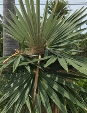
It amazed me that my mother in NC called me while on this remote trail where I saw no one with perfect AT&T reception! At higher elevation service dropped. Prestoea acuminata v. montana everywhere! I am certainly convinced now that one of my previously posted unknown palms on this forum is in fact the "Sierra palm" as they call it, correctly identified on Palmtalk of course!

This trail was really nice although the waterfall before it was a bit underwhelming.post-4111-0-55132000-1439854063_thumb.jp

The next stop for me was a trail to Mina Falls which is highly publicized. I got there early enough to have plenty of parking but by the time I returned (little) tour buses had arrived. Big buses won't fit on these roads but I am used to them by now!

post-4111-0-23918000-1439854309_thumb.jp

This trail was much easier footing and I had a few people ahead of me. It turned out they were from Boston and New Jersey and I loved being able to finally say when asked that I live here! I did admit only 5 weeks after 32 years in Virginia.

post-4111-0-60565700-1439854556_thumb.jp

The falls were nice but even this early I prefer more solitude. There is a waterfall nearly this nice (well actually smaller) walking distance from my farm where there are no rocks and no people that I've ever seen other than when the neighbor showed me (and we haven't been there at the same time since) and folks who I have taken there while visiting. Great little swimming hole whereas Mina Falls has some rocks and swimsuits needed so didn't tempt me.

Hmmm I have no idea why the photo on my iPhone didn't transfer to my Macbook that I am using at the moment? I guess I'll add it later off the phone along with a few others it "missed."

I'll close for now with a couple more. I am sure to return with visitors but I know a bit more to head to the appropriate spots for their footing and stamina and to come early.

post-4111-0-23745800-1439855255_thumb.jp

post-4111-0-20004400-1439855353_thumb.jp

  • Upvote 2

Cindy Adair

  • 4 weeks later...
Posted

Such pretty canopy!  Is there a wet and a dry season, or is the rainfall fairly evenly distributed year round?

Kim Cyr

Between the beach and the bays, Point Loma, San Diego, California USA
and on a 300 year-old lava flow, Pahoa, Hawaii, 1/4 mile from the 2018 flow
All characters  in this work are fictitious. Any resemblance to real persons, living or dead, is purely coincidental.

Posted (edited)

Such pretty canopy!  Is there a wet and a dry season, or is the rainfall fairly evenly distributed year round?

Is a Rain forest but we are under a severe drought. This video show you the difference.


Edited by foxtail

Rio_Grande.gif

  • 2 weeks later...
Posted

Great pic's Cindy

Carlsbad, California Zone 10 B on the hill (402 ft. elevation)

Sunset zone 24

  • 1 month later...
Posted

Thanks for sharing Cindy.  It indeed is a beautiful and interesting place. 

Hawaii Island (Big Island), leeward coast, 19 degrees N. latitude, south Kona mauka at approx. 380m (1,250 ft.) and about 1.6 km (1-mile) upslope from ocean.


No record of a hurricane passing over this island (yet!).  

Summer maximum rainfall - variable averaging 900-1150mm (35-45") - Perfect drainage on black volcanic rocky soil.  

Nice sunsets!

Create an account or sign in to comment

You need to be a member in order to leave a comment

Create an account

Sign up for a new account in our community. It's easy!

Register a new account

Sign in

Already have an account? Sign in here.

Sign In Now


  • Recently Browsing

    • No registered users viewing this page.
×
×
  • Create New...