Jump to content
  • WELCOME GUEST

    It looks as if you are viewing PalmTalk as an unregistered Guest.

    Please consider registering so as to take better advantage of our vast knowledge base and friendly community.  By registering you will gain access to many features - among them are our powerful Search feature, the ability to Private Message other Users, and be able to post and/or answer questions from all over the world. It is completely free, no “catches,” and you will have complete control over how you wish to use this site.

    PalmTalk is sponsored by the International Palm Society. - an organization dedicated to learning everything about and enjoying palm trees (and their companion plants) while conserving endangered palm species and habitat worldwide. Please take the time to know us all better and register.

    guest Renda04.jpg

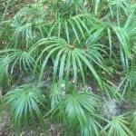
Trying Sabal Minor in the Four Corners region


Southwesternsol

Recommended Posts

Things are looking good, and it's definitely growing. Several inches in just a week or so now that the heat is starting to ramp up. The weeds are also making a come back, unfortunately. Let's just hope next winter is more average

IMG_20240603_123319467_HDR.jpg

  • Like 4
  • Upvote 3
Link to comment
Share on other sites

41 minutes ago, Southwesternsol said:

Things are looking good, and it's definitely growing. Several inches in just week or so now that the heat is starting to ramp up. The weeds are also making a come back, unfortunately. Let's just hope next winter is more average

IMG_20240603_123319467_HDR.jpg

Looking Good! :greenthumb:

  • Like 2
Link to comment
Share on other sites

  • 2 weeks later...
On 10/3/2023 at 2:24 PM, Xerarch said:

These are at the resort at Wahweap, I know I’ve seen others in the area but can’t pinpoint. I also seem to remember some at Bullfrog many years ago, but wasn’t able to find any from Google Earth right now.  If they live at Wahweap they should be able to live virtually anywhere near lake level. 
IMG_2863.thumb.jpeg.4f05e5af4ff1fb151c9f6023c9711809.jpeg

Nice palms - just marked them on Google street view. Definitely should be able to take any of the Lake Powell shoreline areas, those low valleys are all z 8b-ish like here in Las Cruces, only steadier / longer cold, cloudy days during mid-winter.

  • Like 2
Link to comment
Share on other sites

On 12/26/2023 at 11:54 PM, Silas_Sancona said:

That's there in L.C.? ..Ouch 😬 Hopefully ..at least the Pygmy(s) will bounce back, to some deg. at least. ..  Yard definitely could use a bunch of big, canopy creating trees, imo..

Not sure why, but never really had an interest in ..even exploring areas like Prescot / Sedona, or Payson / Pretty much anything north of the valley.. ( Sane thing back home in CA.. Rare that i ventured anywhere north of a line from about Half Moon Bay to Yosemite ) Pretty country up on the Rim for sure,  but, it's the central borderlands region of the state ..Roughly east of Hwy 19 / to roughly west of the San Pedro River that has my undivided attention.  Areas west or east of there are interesting too of course, but, ..just something about that part of the state.

Nothing much of note on this side of the White Mountains either Wx -wise.. A couple nights as low as the mid / upper 30s, but mainly 40s. Mild / warm otherwise.  Far cry so far compared to last year. May be back to 70F as the week, and year ends.

We'll see how Jan. goes.

Update:

Only the Washingtonia filifera survived in that landscape as of May. The winter low in town was 16F-18F (mild, and 25 less freezing nights than average), so that location probably hit 13F~.

The pygmy date and bismarckia palms were completely frozen to the bases each drive by to my MTB trails in Feb-March. All those were pulled and replaced with other plants about May. I'll try to get another photo on my next drive out to the mountain bike trails that direction.

Regular date palms do OK in Las Cruces proper, at least on the bajada above the valley. Canary Island dates do a little better, but I think pygmy dates are marginally freeze hardy in Tucson - maybe 25-30F their limit? But perhaps not, as I don't pay attention to them with so many more interesting plants there.

Agreed - that house needs some appropriate tree canopy or cover. The vast pecan orchards to their west and north provide little benefit, let alone entry experience!

Some comparisons between Tucson (~2500 ft) and Las Cruces (~4000 ft) related to cold hardiness. Same latitude but quite different, and not just they Sonoran Desert Upland and us Chihuahuan Desert:
Tucson AP
16F record low, Jan 1949
27F avg annual low (zone 9b), 11.7 lows / year <32F, 307 day growing season

Las Cruces NMSU
-10F record low, Jan 1962
18F avg annual low (zone 8b), 69.1 lows / year <32F, 241 day growing season

One can see the low temperature we see most years (18) is only 2F warmer than the coldest (16) Tucson has ever gotten in much of town. And the record lowest temps are 26F warmer in Tucson. We get those generational freezes here every 2-3 decades, so marginal palms or other trees here usually won't mature.

  • Like 2
Link to comment
Share on other sites

3 minutes ago, Desert DAC said:

Update:

Only the Washingtonia filifera survived in that landscape as of May. The pygmy date and bismarckia palms were completely frozen to the bases each drive by to my MTB trails in Feb-March.

I think all those were pulled and replaced with other plants about May. I'll need to get another photo on my next drive out to the mountain bike trails that direction. Regular date palms do OK in Las Cruces proper, at least on the bajada above the valley. Canary Island dates do a little better, but I think pygmy dates are iffy in Tucson. But perhaps not, as I  don't pay attention to them with so many more interesting plants there.

Tucson AP

Aahh, bummer on the Bismarckia and Pygmy Date.. 

Agree, wayy too many interesting things to see in Tucson to really pay much attention to any Pygmys around..

Btw, if you hadn't already heard, there's been a pretty big changing of the guard at Desert Survivors.. 

  • Upvote 1
Link to comment
Share on other sites

25 minutes ago, Silas_Sancona said:

Aahh, bummer on the Bismarckia and Pygmy Date.. 

Agree, wayy too many interesting things to see in Tucson to really pay much attention to any Pygmys around..

Btw, if you hadn't already heard, there's been a pretty big changing of the guard at Desert Survivors.. 

I saw that on Instagram, including some folks not too happy on that. I've only been once, but it seems like a cool place.

I added a few items to my reply, which I accidentally clicked tab or send on. That should explain it better.

  • Like 1
Link to comment
Share on other sites

43 minutes ago, Desert DAC said:

Some comparisons between Tucson (~2500 ft) and Las Cruces (~4000 ft) related to cold hardiness. Same latitude but quite different, and not just they Sonoran Desert Upland and us Chihuahuan Desert:
Tucson AP
16F record low, Jan 1949
27F avg annual low (zone 9b), 11.7 lows / year <32F, 307 day growing season

Las Cruces NMSU
-10F record low, Jan 1962
18F avg annual low (zone 8b), 69.1 lows / year <32F, 241 day growing season

One can see the low temperature we see most years (18) is only 2F warmer than the coldest (16) Tucson has ever gotten in much of town. And the record lowest temps are 26F warmer in Tucson. We get those generational freezes here every 2-3 decades, so marginal palms or other trees here usually won't mature.

That makes sense..  Hopefully  your lows will come up a bit more over time..  I thought there was a sliver or two of marginal 9A somewhere near L.C.. Maybe on the western / southern slopes of the Organs?

I'll have to find it again but thought i'd caught sight of a Pygmy in a yard down near Sierra Vista when looking at some other stuff on Street View.. Don't think it looked good though.

 Haven't been able to get down there since last June myself and only heard about the changes when checking in on their FB page / monthly online newsletter. Understand the concern i also saw shared in the comments. Will be interesting to see who fills the void.  Would hate to loose a very valuable source for really hard to find stuff. Bummer too i couldn't stop in and say goodbye.

Guess i need to get on getting my passport / any seed import paperwork i might need to collect /  bring  seed in from Mexico, lol.

  • Upvote 1
Link to comment
Share on other sites

1 hour ago, Silas_Sancona said:

That makes sense..  Hopefully  your lows will come up a bit more over time..  I thought there was a sliver or two of marginal 9A somewhere near L.C.. Maybe on the western / southern slopes of the Organs?

I'll have to find it again but thought i'd caught sight of a Pygmy in a yard down near Sierra Vista when looking at some other stuff on Street View.. Don't think it looked good though.

 Haven't been able to get down there since last June myself and only heard about the changes when checking in on their FB page / monthly online newsletter. Understand the concern i also saw shared in the comments. Will be interesting to see who fills the void.  Would hate to loose a very valuable source for really hard to find stuff. Bummer too i couldn't stop in and say goodbye.

Guess i need to get on getting my passport / any seed import paperwork i might need to collect /  bring  seed in from Mexico, lol.

Those USDA maps use PRISM technology and terrain mapping to infer zone 9a, but there are no stations with readings to support that. On inversion nights, it can be warmer along the base of the Organ Mountains, but each time a cold front moves through, it's colder than anywhere else day and night. Lows were -5 to -11F that area in Feb 2011, plus some isolated -20F lows.  With 80+ consecutive hours below 32F area wide. Killed 1/5 / injured 3/5 native Ferocactus wislizeni, and it froze the tops and buds of some creosote bush stands, which had to re-grow.

No Bismarckia or Phoenix roebelini anytime soon, but we can pull off Brahea armata fine, and probably Chamaerops humilis 'Morrocan Blue'. Loads of choices, with more tolerable summers than Tucson or esp. Phoenix where you can and do grow those other palms.

USDA's latest mapping is an improvement over their 2012 (most of the Organ and Franklin mountains were zone 9, yet other mountains got cooler with elevation as is normal). This new one is still not trained to catch where there are stations to better verify, like colder valley bottom areas here at z 8a and even 7a in central NM around Albuquerque. Central El Paso is probably zone 9a, though the generational freezes killed Parkinsonia florida planted there.

I'll take our stable, rarely up and down winters in our zone 8b any day over the 8a to 9a between Dallas and Austin!

  • Upvote 1
Link to comment
Share on other sites

30 minutes ago, Desert DAC said:

Those USDA maps use PRISM technology and terrain mapping to infer zone 9a, but there are no stations with readings to support that. On inversion nights, it can be warmer along the base of the Organ Mountains, but each time a cold front moves through, it's colder than anywhere else day and night. Lows were -5 to -11F that area in Feb 2011, plus some isolated -20F lows.  With 80+ consecutive hours below 32F area wide. Killed 1/5 / injured 3/5 native Ferocactus wislizeni, and it froze the tops and buds of some creosote bush stands, which had to re-grow.

No Bismarckia or Phoenix roebelini anytime soon, but we can pull off Brahea armata fine, and probably Chamaerops humilis 'Morrocan Blue'. Loads of choices, with more tolerable summers than Tucson or esp. Phoenix where you can and do grow those other palms.

USDA's latest mapping is an improvement over their 2012 (most of the Organ and Franklin mountains were zone 9, yet other mountains got cooler with elevation as is normal). This new one is still not trained to catch where there are stations to better verify, like colder valley bottom areas here at z 8a and even 7a in central NM around Albuquerque. Central El Paso is probably zone 9a, though the generational freezes killed Parkinsonia florida planted there.

I'll take our stable, rarely up and down winters in our zone 8b any day over the 8a to 9a between Dallas and Austin!

You left out a very important option for Las Cruces.. Sabal uresana, ..Kidding of course,  i'm sure you're already aware of that option..

Agree w/ both points regarding the older  ..and newer..  Zone mapping data..  Newer one being better, but still lacking that extra -finite scale ability that currently doesn't pick out the really micro micro-climate level aspects like the chillier canyon / valley bottoms that can be surrounded by slightly warmer areas -that might mask the cold spots- all that well.

Even here, that fine scale detail isn't as perfect as it could be / may be in the future.. I honestly would have expanded 10 further into the E. Valley on it.

Cold enough to nip Creosote / kill Ferocactus is darn cold, lol..  Hopefully that doesn't happen again.

Agree, it may be hot as hell here for a few weeks ( months ), but,  at least i don't have to worry as much about any random extreme cold spells, or everything i own being completely obliterated during a hurricane..  I can deal w/ it not raining as much as it can in those warmer 9b / 10A/B  areas.

  • Upvote 1
Link to comment
Share on other sites

17 hours ago, Silas_Sancona said:

You left out a very important option for Las Cruces.. Sabal uresana, ..Kidding of course,  i'm sure you're already aware of that option..

Agree w/ both points regarding the older  ..and newer..  Zone mapping data..  Newer one being better, but still lacking that extra -finite scale ability that currently doesn't pick out the really micro micro-climate level aspects like the chillier canyon / valley bottoms that can be surrounded by slightly warmer areas -that might mask the cold spots- all that well.

Even here, that fine scale detail isn't as perfect as it could be / may be in the future.. I honestly would have expanded 10 further into the E. Valley on it.

Cold enough to nip Creosote / kill Ferocactus is darn cold, lol..  Hopefully that doesn't happen again.

Agree, it may be hot as hell here for a few weeks ( months ), but,  at least i don't have to worry as much about any random extreme cold spells, or everything i own being completely obliterated during a hurricane..  I can deal w/ it not raining as much as it can in those warmer 9b / 10A/B  areas.

Sabal uresana is worth a try, as the few Sabal palmetto and S. mexicana established here are vigorous or healthy. Our local growers and market size (?) limit choices, unfortunately!

The colder drainages or thermal belts in NM are miles long, so much larger than microclimate scale. Computer mapping is good and improving, but it has a way to go. Especially without enough data for a long enough time, not to mention occasional human bias as an input. The Phoenix valley sounds like it wasn't fine-tuned, either. 

I think Las Cruces is safe from a big freeze for another decade or so, but those do help people (who want to) know better plant choices. So much more potential here in our native flora alone, than what growers sell.

Your area may have searing summers, but the no (real) winter part compensates. 

  • Like 1
  • Upvote 1
Link to comment
Share on other sites

@Desert DAC

@Silas_Sancona

Speaking about PHX, Las Cruces, and my own area regarding the zones.  Much of these places are so newly settled, that there is no (decade/s)record to rely upon regarding weather data. 

So a lot is assumption(human bias). 

Interesting in my area is KABQ all-time record high is 107f.  A one time deal years ago. . Yet it was 106f last week at Rio Rancho #2, my neighborhood, which is not unusual, and  actually goes against human bias or what the local meteorologists will report/predict.  But the data, which is not long,(couple decades) is showing something not known or thought. 


Link to comment
Share on other sites

1 minute ago, jwitt said:

@Desert DAC

@Silas_Sancona

Speaking about PHX, Las Cruces, and my own area regarding the zones.  Much of these places are so newly settled, that there is no (decade/s)record to rely upon regarding weather data. 

So a lot is assumption(human bias). 

Interesting in my area is KABQ all-time record high is 107f.  A one time deal years ago. . Yet it was 106f last week at Rio Rancho #2, my neighborhood, which is not unusual, and  actually goes against human bias or what the local meteorologists will report/predict.  But the data, which is not long,(couple decades) is showing something not known or thought. 


Can't speak for areas of N.M. but Wx records for both Phoenix and Tucson ( possibly some other areas of the state ) go back to the 1800's  That's a good amount of time to pull " modern era " data from.

Can also use other longer term thoughts from Tree ring and Pack Rat Midden data to get a good idea of what the climate was like / how it has ..and will continue to change.

More data being collected from leaf wax, seafloor / lake bed sediment cores, and stalagmite / -tites  that i'm sure will go into Wx modeling in the future.

On that point, As Desert DAC mentions, while the new maps are decent,  more detailed ..anaccurate.. data will come about as finer scale modeling / data improves w/ time. The same thing is a major challenge  atm in looking at what the Monsoon will do in the future, let alone year to year forecasting of it. 

That said, nothing will ever be perfect.  Perfect would've be an arm of the Gulf of CA extending all the way to both the west side of Tucson, and just across the 202 here, lol. 

Link to comment
Share on other sites

On 6/3/2024 at 12:40 PM, Southwesternsol said:

Things are looking good, and it's definitely growing. Several inches in just a week or so now that the heat is starting to ramp up. The weeds are also making a come back, unfortunately. Let's just hope next winter is more average

IMG_20240603_123319467_HDR.jpg

I imagine in a couple years, after your palm "settles" in, it may laugh at even some of your "abnormal" years. 


  • Upvote 1
Link to comment
Share on other sites

35 minutes ago, Silas_Sancona said:

Can't speak for areas of N.M. but Wx records for both Phoenix and Tucson ( possibly some other areas of the state ) go back to the 1800's  That's a good amount of time to pull " modern era " data from.

Can also use other longer term thoughts from Tree ring and Pack Rat Midden data to get a good idea of what the climate was like / how it has ..and will continue to change.

More data being collected from leaf wax, seafloor / lake bed sediment cores, and stalagmite / -tites  that i'm sure will go into Wx modeling in the future.

On that point, As Desert DAC mentions, while the new maps are decent,  more detailed ..anaccurate.. data will come about as finer scale modeling / data improves w/ time. The same thing is a major challenge  atm in looking at what the Monsoon will do in the future, let alone year to year forecasting of it. 

That said, nothing will ever be perfect.  Perfect would've be an arm of the Gulf of CA extending all the way to both the west side of Tucson, and just across the 202 here, lol. 

Yes our records here also go way back. But are not as useful as say PHX. Because here, while our cities are actually much older than Phx,  the difference between our downtown(old station)/airport(new station) can be near or more than a complete zone. 

Would be like using Tucson data until moved to sky harbor.  

And what I imagine in the PHX metro; in the future as it expands, maybe a good 10b exists out by Saguaro lake, S mountain, or near the superstitions.  And as it develops, that unexpected 10b becomes nearly an 11b.  

Unknown thermal belts in the PHX metro as it expands into previously uninhabited and increased terrain "areas".  Unbeknownst to common thought. 

 My thoughts. 

As to the newest zone map, it has become less accurate for my metro.  Infact, the double eagle airport station easily proves this.  Map says 7b, station data says 6b. 

Link to comment
Share on other sites

14 hours ago, jwitt said:

Yes our records here also go way back. But are not as useful as say PHX. Because here, while our cities are actually much older than Phx,  the difference between our downtown(old station)/airport(new station) can be near or more than a complete zone. 

Would be like using Tucson data until moved to sky harbor.  

And what I imagine in the PHX metro; in the future as it expands, maybe a good 10b exists out by Saguaro lake, S mountain, or near the superstitions.  And as it develops, that unexpected 10b becomes nearly an 11b.  

Unknown thermal belts in the PHX metro as it expands into previously uninhabited and increased terrain "areas".  Unbeknownst to common thought. 

 My thoughts. 

As to the newest zone map, it has become less accurate for my metro.  Infact, the double eagle airport station easily proves this.  Map says 7b, station data says 6b. 

If even half of the suggested growth occurs around the valley by 2040 or 50,  we'll be well into 10 ..if not 11 / maybe flirting with 12... for many of the already developed areas in town now,  borderline 10 ..or just above that in currently 9B areas on the fringes. Superior and areas just east of Florence i walk are already 9B w/ out much development. No need to use temp. data to see that, specific plants growing out there show it. 

Corridor between Florence / Coolidge, Casa Grande / Maricopa, and the " north of Tucson  'burbs " will be solid 9b / flirting with 10.

Closer to here, once the 24 is finally extended to where the 60 and 79 meet, out by where the Ren Fair is held  / that whole area of currently open desert between Florence and Apache Junction starts rapidly filling in? ( Several companies already proposing big developments out there now )    kiss that valley cool pocket good- bye- 

W/ out that cool pocket, gonna be really tough to see lows below 25F ever again in this part of the valley.  ( well, in my lifetime -at least, lol )

Fyi: if making any trips out here over the next two years, section of the 202 passing through this part of the valley is about to become a major mess..  On top of other stuff planned, state is adding two more lanes / lanes to on and off ramps in each direction from where the 202 meets the 101 out to near Queen Creek.

Regardless, stuff like Mangoes, Plumeria, Royal Poinciana / other Delonix sps i'm growing ..and a couple things i have that originate in zone 12/ 13 areas of Southwest Mexico have done fine so, i'm perfectly content as is.. Only gets better from here.   Monsoon Season rainfall may increase over time too.


  • Like 1
Link to comment
Share on other sites

@Silas_Sancona

Thanks for the 202 update. Visit often to far east Mesa area and Chandler. 

  • Like 1
Link to comment
Share on other sites

On 6/12/2024 at 9:37 PM, jwitt said:

I imagine in a couple years, after your palm "settles" in, it may laugh at even some of your "abnormal" years. 


Hopefully, I know they're often a little more sensitive when young and/or recently planted.

  • Like 1
  • Upvote 1
Link to comment
Share on other sites

Create an account or sign in to comment

You need to be a member in order to leave a comment

Create an account

Sign up for a new account in our community. It's easy!

Register a new account

Sign in

Already have an account? Sign in here.

Sign In Now


  • Recently Browsing

    • No registered users viewing this page.
×
×
  • Create New...